Paddling Through Time: Exploring the New River Gorge’s Historic Waterways
August 31, 2023Dive into a world where modern-day adventure meets deep history, and ride the waves of the New and Gauley rivers. Discover how these waterways have shaped the region’s narrative, from ancient indigenous cultures to the pioneering spirit of early settlers. It’s not just about paddling – it’s about learning the stories of these waters.
The New River
The New River stands out as one of the United States’ most picturesque and historically significant rivers. Stretching across a length of 320 miles, this ancient river has flowed for millions of years. Remarkably, it ranks among the world’s five oldest rivers on Earth, with many geologists estimating the river to be between 10 and 360 million years old.
Beginning its course in the Blue Ridge Mountains of North Carolina, the New River flows in a south-to-north course (differing from the west-to-east flow of most other major rivers). The New River flows through North Carolina, Virginia and West Virginia before joining with the Gauley River to form the Kanawha River.
Centuries before pioneers arrived, Native Americans utilized the New River as a westward passage. In the 1600s, explorers navigating the river’s westerly course mistakenly believed they were near the Pacific Ocean, coining themselves the “men of the western waters.” In 1671, the Batts-Fallam expedition charted a route along the New River, reaching the Lurich area in Virginia, where their journey concluded due to the reluctance of their Native American guides. Marking their presence by carving initials into a tree, they claimed the territory for King Charles II of England. This proclamation marked the earliest English assertion of land west of the Alleghenies, establishing the New River as the inaugural gateway to the West.
The origins of the ironic name are unclear. One tale suggests that its name originated from a translation of a Native American dialect, signifying “new waters.” Another narrative recounts Captain Byrd’s involvement in establishing a road from the James River to Abingdon, Virginia, in 1764. While consulting the Fry-Jefferson Map of 1755, crafted by Joshua Fry and Peter Jefferson (the father of Thomas Jefferson), Captain Byrd was unable to locate the river as shown on the map, leading him to call it the “New River.” The New River has previously been known as the Conhaway River, Great Konhaway River, Kunhaway River and Wood River.
The New River boasts natural wonders unique to West Virginia. The passage through the Gorge unveils an increasingly profound descent into West Virginia’s captivating canyons, with depths reaching an impressive 1,600 feet from the riverbed to the nearest plateau. Commencing its flow below the Bluestone Dam in Hinton, the Gorge’s course culminates at U.S. Route 19 in Fayette County. Here, find the iconic New River Gorge Bridge, a monumental structure that not only facilitates access but also offers a breathtaking vantage point to admire the Gorge.
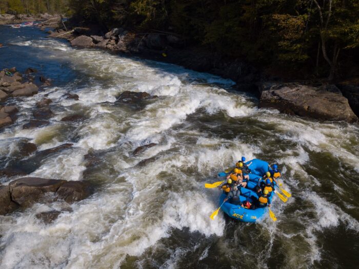
The New River Gorge beckons adventure enthusiasts with a variety of whitewater activities like rafting and kayaking. Along the Gorge’s rim, numerous open ledges offer popular viewpoints, including well-loved spots such as Hawks Nest State Park and various overlooks within the New River Gorge National Park and Preserve.
The Gauley River
The Gauley River and its gorge have served as both a barrier and a pathway for human endeavors. Native Americans relied on the area for fishing and hunting for over 10,000 years, while European settlers began populating the region in the late 1700s. In 1861, the confluence of the Gauley and Meadow rivers witnessed a significant Civil War battle, and the area now resides within Carnifex Ferry Battlefield State Park.
Believed to draw its name from “Gaul,” a historical European region encompassing present-day France, the Gauley River’s origins can be traced back to the era when West Virginia was a part of New France before the French and Indian War. Throughout its history, the river has carried various Native American titles, as well as alternate spellings such as Gaul/Gauley and Falling/Falls Creek.
The Gauley River stretches over a length of 105 miles, originating in the Monongahela National Forest on Gauley Mountain. Its principal tributaries, flowing from the east, include the Williams, Cranberry, Cherry and Meadow rivers.
Summersville Dam, an engineering feat by the U.S. Army Corps of Engineers, regulates the Gauley River, forming the expansive Summersville Lake. Downstream from the dam lies the Gauley River National Recreation Area, offering a haven for outdoor enthusiasts.
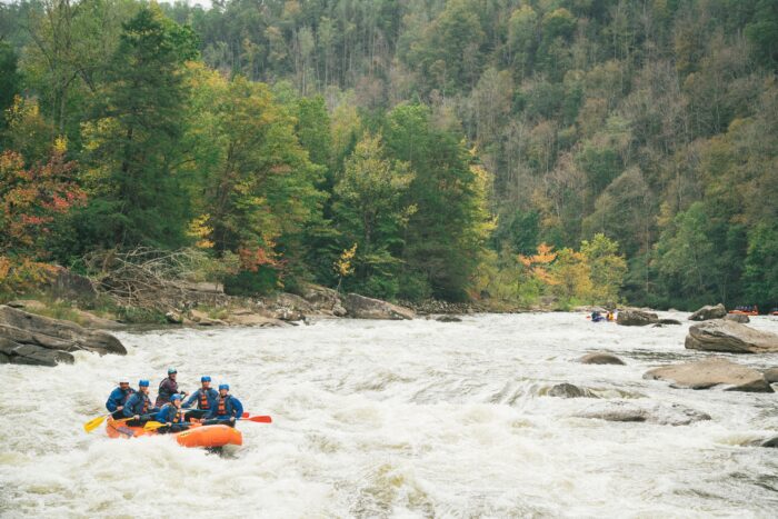
Lovers of recreational boating navigate the Gauley River year-round, with commercial rafting companies operating primarily from spring to fall. Recreational usage is heavily influenced by water levels, which experience substantial fluctuations due to rainfall and Summersville Lake’s level. Notably, Gauley Season, spanning eight consecutive weekends starting the Friday following Labor Day, sees controlled releases by the Army Corps of Engineers.
Other Waterways
In addition to rivers, the New River Gorge area is home to many scenic creeks, including Dunloup, Glade, Meadow, Mill and Wolf. These creeks are known for their stunning waterfalls, popular swimming holes, excellent fishing spots and a variety of other recreational activities. Additionally, Boley Lake, found within Babcock State Park, and Hawks Nest Lake each offer tranquil waters that reflect the serene beauty of their natural surroundings.
From flatwater paddling to intense whitewater adventures – the New River Gorge area is an aquatic oasis. Now that you’re acquainted with New River Gorge’s waterway history, request a copy of our free travel guide to kickstart your adventure planning.
Want to see more from our team? Save our blog as a preferred source in Google